
The Geography of the Bible
Where the Ancient World of Scripture Sits on Today’s Map
When people read the Bible, it is easy for its place names to blend into the background. Canaan, Babylon, Moab, Galilee, Nineveh and Ephesus can begin to sound like distant religious settings rather than locations that once existed in the same physical world we live in today. But these were real places connected by mountains, rivers, deserts, ports and heavily travelled roads. Some of their names have disappeared from modern maps, while others—including Jerusalem, Bethlehem, Gaza, Damascus, Egypt and Rome—remain immediately recognizable. In some cases, a modern city sits directly over or beside its ancient predecessor. In others, archaeologists have identified ruins near a present-day town. A smaller number of famous biblical locations remain mysterious, with scholars still debating exactly where they were.
Understanding the geography of the Bible can completely change the way its stories feel. Abraham’s journey becomes a long movement through areas that are now part of Iraq, Türkiye, Syria and the Holy Land. The ancient kingdoms surrounding Israel become recognizable parts of Jordan, Lebanon and Syria. Paul’s missionary journeys become ambitious Mediterranean voyages through modern Türkiye, Greece, Cyprus, Malta and Italy. The world of the Bible was not imaginary, isolated or especially small. It was part of a busy and interconnected region where continents, kingdoms, cultures and trade routes met.
Biblical Lands Do Not Match Modern Borders
Before placing biblical locations on today’s map, it is important to remember that modern countries did not exist during biblical times. There was no country called Iraq, Israel, Jordan, Lebanon, Syria, Türkiye or Italy in the modern political sense. The borders of kingdoms and empires changed repeatedly. Cities were conquered, abandoned, rebuilt and renamed, and a place might belong to several different empires over the course of its history.
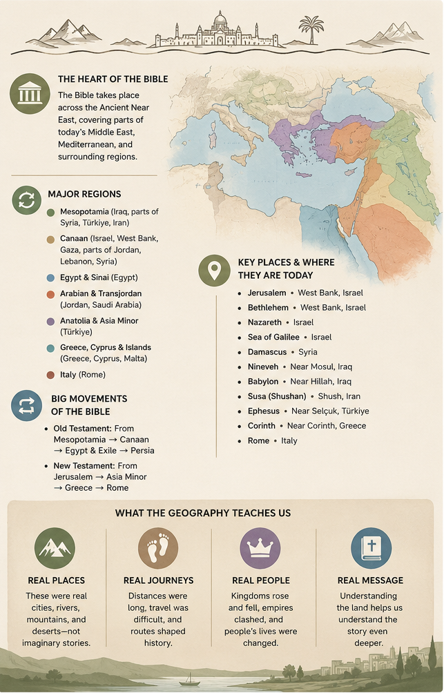
Most biblical events occurred in a region historians call the Ancient Near East. This broad area included Egypt, the eastern Mediterranean coast, Mesopotamia, Anatolia and Persia. On today’s map, it covers parts of Egypt, Israel, the Palestinian territories, Jordan, Lebanon, Syria, Iraq, Iran, Türkiye and Cyprus. The central part of this world was the Levant, a narrow region along the eastern coast of the Mediterranean Sea that acted as a natural bridge between Africa, Asia and Europe. Egypt lay to the southwest, Mesopotamia and Persia lay to the east, and Anatolia and the wider Mediterranean world lay to the north and west.
This location made the lands of Israel and Judah strategically important, but it also made them vulnerable. Armies travelling between Egypt and the great empires of Mesopotamia frequently passed through or near their territory. Geography therefore helps explain why these relatively small kingdoms were so often caught between much larger powers.
Mesopotamia: The Eastern Beginning of the Biblical World
Some of the earliest biblical stories are connected with Mesopotamia, the region surrounding the Tigris and Euphrates rivers. The name Mesopotamia means “land between the rivers,” and the region covered most of present-day Iraq as well as portions of northeastern Syria, southeastern Türkiye and western Iran.
The Book of Genesis mentions the Tigris and Euphrates in its description of the Garden of Eden. Because these rivers are real, many people have attempted to locate Eden somewhere in or around Mesopotamia. However, the other rivers mentioned in the account cannot be identified with enough certainty to locate Eden on a modern map. Mesopotamia may provide a general geographical setting for the story, but claims that the exact location of Eden has been discovered should be treated cautiously.
Another important Mesopotamian location is Ur of the Chaldeans, the homeland associated with Abraham. Ur is commonly identified with an ancient city near modern Nasiriyah in southern Iraq. The archaeological site, known today as Tell el-Muqayyar, was once a major Sumerian city near the Euphrates River. Not every scholar agrees that this southern city was Abraham’s Ur, and alternative locations in northern Mesopotamia have also been suggested. Nevertheless, the southern Iraqi site remains the best-known identification.
Abraham’s family later travelled to Haran, an ancient city strongly associated with modern Harran in southeastern Türkiye, not far from the Syrian border. From Haran, Abraham continued toward Canaan. Placed on a modern map, this was an enormous journey that may have carried Abraham and his household across parts of modern Iraq, Türkiye and Syria before they reached the land now associated with Israel and the Palestinian territories.
Babylon and Nineveh in Modern Iraq
Two of the Bible’s most famous cities were located in what is now Iraq. Babylon stood beside the Euphrates River approximately 85 kilometres south of modern Baghdad, near the present-day city of Hillah. Babylon appears repeatedly throughout the Bible. The region is traditionally associated with the Tower of Babel, and much later it became the centre of the empire ruled by Nebuchadnezzar II. Babylonian forces conquered the Kingdom of Judah, destroyed the First Temple in Jerusalem and carried many Judeans into exile. The books of Daniel and Ezekiel are closely connected with this period. The ruins of Babylon still exist, and visitors and archaeologists can see remains associated with its walls, palaces, temples and monumental gates.
Nineveh was located much farther north. The ancient Assyrian capital stood beside the Tigris River, directly across from the centre of modern Mosul in northern Iraq. Nineveh is especially famous as the city to which the prophet Jonah was sent. It is important not to confuse Assyria with Babylonia, because they were separate civilizations centred in different parts of Mesopotamia. Assyria’s heartland was mainly in northern Iraq, and the Assyrian Empire conquered the northern Kingdom of Israel during the eighth century BCE. Babylonia was centred farther south, and more than a century after Israel fell to Assyria, the Babylonian Empire conquered Judah and Jerusalem. Understanding this north-south separation makes many Old Testament events easier to follow.
Persia and Biblical Locations in Modern Iran
After Babylon was conquered by the Persian Empire, the biblical world expanded farther east into what is now Iran. One of the most important Persian cities in the Bible was Susa, also called Shushan. The ruins of Susa are located beside the modern Iranian city of Shush in southwestern Iran. Susa appears prominently in the Book of Esther and is also connected with the stories of Daniel and Nehemiah.
The events described in Esther did not take place in Jerusalem or somewhere nearby. They unfolded within a Persian royal centre hundreds of kilometres east of Babylon. Nehemiah was also serving the Persian king in Susa when he learned that the walls of Jerusalem were still broken down. His eventual journey to Jerusalem therefore involved crossing a significant portion of the Persian Empire.
The ancient region of Elam was also located mainly in southwestern Iran. Persia itself eventually controlled a vast empire stretching from Central Asia and Iran to Egypt, Anatolia and the Aegean coast. This means that during the Persian period, many of the people and places mentioned in the Bible were part of one enormous political system.
Canaan: The Central Land of the Bible
Canaan is one of the most frequently mentioned regions in the Bible, but it does not correspond perfectly to any single modern country. The ancient land of Canaan generally included territory west of the Jordan River and neighbouring areas along the eastern Mediterranean. On today’s map, it covered much of Israel, the West Bank and Gaza, as well as portions of Jordan, Lebanon and Syria. Its borders were never completely fixed and changed depending on the historical period and the source describing them.
This relatively small region contains a remarkable variety of landscapes. The Mediterranean coastline is largely flat and fertile. Farther inland, hills rise through Samaria and Judea. To the east, the land drops dramatically into the Jordan Valley and the Dead Sea basin. The Negev desert lies to the south, leading toward the Sinai Peninsula and Egypt.
These physical features had an enormous influence on biblical events. Mountains provided natural protection, valleys became invasion routes and springs determined where cities could survive. Deserts offered refuge, but they also presented serious dangers. Coastal ports connected Canaan to the wider Mediterranean world. Geography was never merely background scenery. It shaped where people lived, where armies travelled, how kingdoms defended themselves and which cities became wealthy or strategically important.
Jerusalem, Bethlehem, Hebron and Jericho
Jerusalem stands in the Judean hills between the Mediterranean Sea and the Dead Sea. It became the political capital of the Kingdom of Judah and the religious centre associated with the Temple. In the New Testament, Jerusalem became the destination of Jesus’ final journey and the starting point for the early Christian movement described in the Book of Acts.
Bethlehem lies approximately 10 kilometres south of Jerusalem in the West Bank. The town is associated with Ruth, King David and the birth of Jesus. The Church of the Nativity stands in Bethlehem and marks the traditional location of Jesus’ birth. Hebron, also known as Al-Khalil, is located farther south in the West Bank and is closely connected with Abraham, Sarah, Isaac, Rebekah, Jacob and Leah. The Cave of the Patriarchs, also called the Ibrahimi Mosque, is traditionally believed to contain their burial places.
Jericho lies northeast of Jerusalem in the Jordan Valley, close to the northern end of the Dead Sea. Ancient Jericho is identified with Tell es-Sultan, an archaeological mound near the modern city. The area contains evidence of human settlement going back thousands of years before the biblical period.
The road between Jerusalem and Jericho appears in the parable of the Good Samaritan, and its geography helps explain the story. Jerusalem is high in the Judean hills, while Jericho is far below sea level. Travellers had to descend through steep, dry and isolated terrain where robbery, injury and exposure were genuine dangers.
Galilee, Nazareth and the Sea of Galilee
Much of the ministry of Jesus took place in Galilee, a region located mainly in northern Israel. Nazareth remains a living city in the hills of Lower Galilee and was the hometown with which Jesus was most closely associated. The Sea of Galilee lies to the east of Nazareth. Despite its name, it is a freshwater lake rather than a sea, and it is both fed and drained by the Jordan River.
Several communities mentioned in the New Testament stood around its shores. Capernaum was located on the northwestern side of the lake, and its ruins can still be visited today. Magdala, associated with Mary Magdalene, was located along the western shoreline. The lake supported fishing communities and provided transportation between nearby settlements. Sudden winds descending from the surrounding highlands could also create dangerous storms, adding geographical context to the New Testament accounts of storms on the water.
Farther north stood Caesarea Philippi near the springs feeding the Jordan River at the base of Mount Hermon. This lush, rocky and mountainous setting was very different from the dry landscapes farther south around Jerusalem and the Dead Sea.
Samaria and the Central Hill Country
Samaria was located between Galilee in the north and Judea in the south. The term could refer both to a broad region and to the capital city of the ancient northern Kingdom of Israel. The ruins of the city of Samaria are found near the modern West Bank village of Sebastia.
Another important city in the region was Shechem, commonly identified with Tell Balata beside modern Nablus. Shechem appears in stories involving Abraham, Jacob, Joshua and the division of the Israelite kingdom. Nearby Mount Gerizim remains sacred to the Samaritan community.
Samaria’s geographical position made it an important passageway between Galilee and Jerusalem. Travellers could pass directly through Samaria, take a longer route east of the Jordan River or move closer to the Mediterranean coast. Social tensions between Jewish and Samaritan communities made these travel decisions more significant than they might appear on a simple map.
Philistia, Gaza and the Mediterranean Coast
The biblical land of Philistia occupied part of the southern Mediterranean coastline. Its five principal cities were Gaza, Ashkelon, Ashdod, Ekron and Gath. Modern Gaza occupies the same general location as the ancient city and is now part of the Gaza Strip. Ashkelon and Ashdod are cities in present-day Israel. Ekron is generally identified with the archaeological site of Tel Miqne, while Gath, the city associated with Goliath, is commonly identified with Tell es-Safi.
Farther north, the biblical port of Joppa survives as Jaffa, now part of Tel Aviv-Yafo. Joppa was the port through which timber was brought for the Temple in Jerusalem, and it was also where Jonah boarded a ship while attempting to flee from his mission to Nineveh. In the New Testament, Joppa was the setting of Peter’s vision in the Book of Acts.
The Mediterranean was not simply the western edge of the biblical world. It was a major highway connecting the Levant with Egypt, Cyprus, Anatolia, Greece, Italy and North Africa. Coastal cities often became wealthy because they connected inland kingdoms with the wider world.
Moab, Ammon, Edom and Gilead in Modern Jordan
A surprising amount of biblical history took place east of the Jordan River in what is now Jordan. Ammon was centred around the ancient city of Rabbah, which developed into modern Amman, the capital of Jordan. Ancient remains can still be seen around the Amman Citadel.
Moab occupied the highlands east of the Dead Sea in central-western Jordan. Ruth was a Moabite woman, and the Israelites camped on the plains of Moab before crossing the Jordan River into Canaan. Mount Nebo, traditionally associated with Moses viewing the Promised Land before his death, is located in this region near the modern city of Madaba.
Edom lay farther south, extending through the rugged territory of southern Jordan and toward the Arabah Valley. The Edomites were traditionally connected with Esau, Jacob’s brother. Their territory included mountainous landscapes and routes leading toward the Red Sea. Gilead referred to a hilly region east of the Jordan River, particularly in northern Jordan. It was known for pasturelands, forests and the famous “balm of Gilead.”
Once these places are positioned on a modern map, they no longer appear like remote or mysterious civilizations. Moab, Ammon, Edom, Judah and Israel were neighbouring territories separated by rivers, ridges, valleys and desert landscapes.
Lebanon and Syria in the Bible
The ancient cities of Tyre and Sidon remain cities in modern Lebanon. Both were major Phoenician ports. Tyre supplied timber and skilled workers for Solomon’s building projects, while both cities appear in prophetic writings and New Testament accounts of Jesus travelling through the surrounding region.
Behind the coast rose the mountains of Lebanon. The famous cedars of Lebanon provided valuable timber for palaces, ships and temples. Large construction-quality trees were not equally available throughout the ancient Near East, making Lebanon’s forests an important economic and strategic resource.
Damascus remains the capital of modern Syria. It appears in both the Old and New Testaments and has been inhabited for thousands of years. In the Book of Acts, Saul was travelling toward Damascus when he experienced the encounter that led to his conversion. He later became known as Paul.
One location that often surprises modern readers is Antioch. The influential New Testament city commonly called Antioch in Syria is not located within the borders of modern Syria. Its ruins are near Antakya in southern Türkiye, close to the present Syrian border. Antioch became one of the most important centres of early Christianity and a major starting point for Paul’s missionary journeys.
Egypt and the Uncertain Route of the Exodus
Biblical Egypt corresponds broadly to the modern country of Egypt, although ancient settlement was concentrated much more heavily along the Nile River and its delta. The land of Goshen, where the Israelites lived before the Exodus, is generally placed in the eastern Nile Delta, although its exact boundaries remain uncertain.
The Exodus story then moves eastward toward the wilderness and the Sinai Peninsula. The traditional location of Mount Sinai is Jebel Musa in southern Sinai, near Saint Catherine’s Monastery. However, the Bible does not provide enough geographical information to identify the mountain with certainty. Other proposed locations can be found elsewhere in Sinai, the Negev desert and northwestern Arabia.
The exact route of the Exodus is also debated. The body of water traditionally called the Red Sea may have referred to a sea, lake or marshy region closer to the Egyptian delta. The Hebrew phrase is often translated as the “Sea of Reeds.” Any modern map showing one exact Exodus route should therefore be viewed as a reconstruction rather than a confirmed path.
Türkiye: A Major Centre of the New Testament
Modern Türkiye contains an extraordinary number of important New Testament locations. Ancient Asia Minor covered most of the peninsula that now forms Türkiye. Paul was born in Tarsus, near the modern Turkish city of the same name. Antioch was located near modern Antakya, and large portions of Paul’s missionary journeys took place in cities that are now archaeological sites across Türkiye.
The seven churches addressed in the Book of Revelation were all located in western Türkiye. Ephesus is near modern Selçuk, Smyrna became İzmir, Pergamum is near Bergama, Thyatira is associated with Akhisar, Sardis is near Sart, Philadelphia became Alaşehir and Laodicea is located near Denizli.
Ephesus was one of the largest and most influential cities in the Roman province of Asia. Its surviving ruins include streets, houses, temples and an enormous theatre. Walking through Ephesus today offers one of the clearest opportunities to experience the scale and complexity of a New Testament city.
The island of Patmos, where the Book of Revelation says John received his visions, belongs to modern Greece. However, it sits just off the western coast of Türkiye.
Greece, Cyprus, Malta and Rome
Paul’s journeys eventually carried the New Testament story westward across the Mediterranean. On the island of Cyprus, Paul visited Salamis in the east and Paphos in the west, and both locations can still be connected with identifiable archaeological remains.
In northern Greece, ancient Philippi lies near the modern city of Kavala. Thessalonica became modern Thessaloniki, while Berea is identified with modern Veria. Athens remains Athens, and Paul’s speech at the Areopagus took place in a city already famous for philosophy, temples and public debate.
Ancient Corinth stood near the modern Greek city of Corinth. Its position beside the narrow land bridge joining mainland Greece to the Peloponnese made it an important centre of trade and travel. Paul later sailed toward Italy and was shipwrecked on Malta. The exact location of the shipwreck remains debated, although Saint Paul’s Bay is the traditional site.
The Book of Acts ends with Paul in Rome, the capital of the Roman Empire and the modern capital of Italy. By this point, the geographical centre of the biblical story had shifted dramatically. It began in Jerusalem, moved through Judea and Samaria, continued through Syria and Türkiye, crossed Greece and the Mediterranean, and finally reached Rome.
Biblical Places That Remain Uncertain
Not every location mentioned in the Bible can be confidently placed on a modern map. The location of the Garden of Eden remains unknown. The exact sites of Sodom and Gomorrah are still debated. Mount Sinai has several proposed locations, and the route of the Exodus cannot be reconstructed with certainty.
Emmaus, where two disciples encountered the risen Jesus, has been associated with several different sites. Ophir, famous for its gold, has been placed in locations ranging from Arabia and East Africa to India. Tarshish is often connected with southern Spain, particularly the ancient region of Tartessos, but other Mediterranean locations have also been proposed. Jonah may have been attempting to travel toward the far western edge of the known world, but saying with certainty that he was heading to Spain goes beyond the available evidence.
This uncertainty does not make biblical geography less interesting. It makes honesty more important. A useful biblical map should distinguish between places that remain inhabited, locations strongly identified through archaeology, sites based largely on tradition and genuine mysteries that remain unresolved.
Seeing the Bible as a Real Landscape
One of the easiest ways to understand biblical geography is to picture two great movements. The Hebrew Bible often follows an eastern arc. The story moves from Mesopotamia in modern Iraq toward Haran in Türkiye, southwest through Syria and into Canaan. At other times, people travel south toward Egypt or are carried east into exile in Assyria, Babylon and Persia.
The New Testament begins mainly in Galilee and Judea. From there, the story expands northward through Syria and Türkiye, westward through Greece and the Mediterranean islands, and finally toward Rome.
Once this basic map settles into your mind, many biblical place names become much easier to remember. Nineveh was beside modern Mosul in Iraq. Babylon was south of Baghdad. Susa was in Iran. Haran was in Türkiye. Moab and Ammon were in Jordan. Tyre and Sidon were in Lebanon. Damascus was in Syria. Bethlehem, Jericho and Hebron are in the West Bank. Nazareth and the Sea of Galilee are in northern Israel. Ephesus was in Türkiye. Corinth and Philippi were in Greece. Rome was, and remains, in Italy.
The stories of the Bible did not happen in an imaginary fog. They unfolded along mountain roads, across desert wildernesses, beside major rivers and within crowded cities and ports. People travelled distances that would have required weeks or months on foot. Kingdoms fought to control valleys and trade routes, while cities grew around springs, harbours and defensible hills.
Reading the Bible with a map nearby does more than teach geography. It reveals the distances, risks, political pressures and cultural connections hidden behind familiar stories. The places stop feeling like names from another world and begin to feel like parts of the same world we still inhabit today.
Crazy to think the vast land the stories of the bible encompasses. It must have been a pain making sense of all the different languages spoken in those various places to end up with a bible told strictly in one language.