
Super El Niño 2026: What It Could Mean for the World
When a major heatwave hits Europe, Ontario gets sticky and dangerously hot, wildfires start making headlines, and social media begins throwing around terms like “super El Niño,” it is natural to wonder whether one huge weather event is affecting the entire planet.
The honest answer is: partly—but not in the simple way headlines often make it sound.
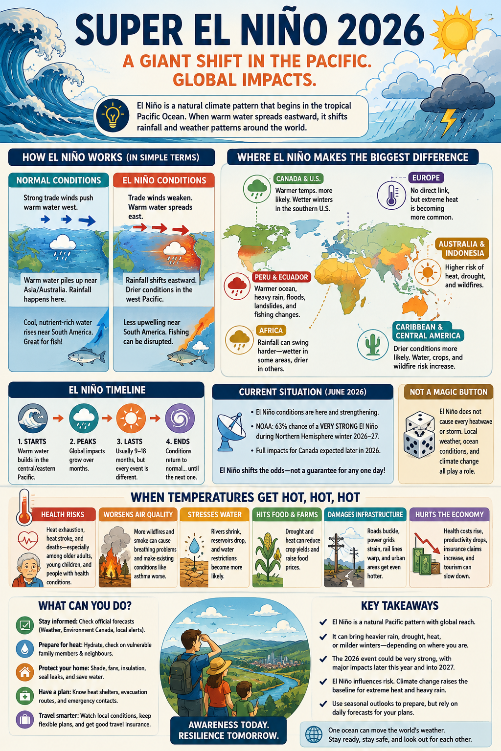
El Niño is one of the world’s most powerful natural climate patterns. It begins in a specific part of the tropical Pacific Ocean, yet it can shift rainfall, heat, storm tracks, fisheries, farming conditions, wildfire risk, and travel plans thousands of kilometres away. In June 2026, official forecasting agencies confirmed that El Niño conditions are developing and could strengthen substantially later this year. NOAA’s June outlook gave a 63% chance of a very strong El Niño during the Northern Hemisphere winter of 2026–27.
That does not mean every hot day, flood, drought, or storm this year can be blamed on El Niño. Weather is messy. A local heatwave can be driven by a stagnant high-pressure system, dry soil, warm nearby water, urban heat, or a particular jet-stream pattern. But El Niño can change the background odds—making certain types of extreme weather more likely in some places and less likely in others.
Quick Answer: Is El Niño a Global Event?
Yes. El Niño begins in the tropical Pacific but can influence weather patterns around much of the planet.
Here is the simple version:
- It starts with unusually warm water in the central and eastern tropical Pacific Ocean.
- That warm water shifts where tropical rainstorms form.
- Those changed rainstorms alter high-altitude winds and weather patterns around the world.
- Some places become wetter, some drier, some hotter, and some see little obvious change.
- The strongest effects often appear months after El Niño begins—not necessarily the same week people first hear about it.
For 2026, El Niño is developing during the summer, but many of its more recognizable global effects may become clearer in late 2026 and into 2027.
First, What Does “Super El Niño” Actually Mean?
“Super El Niño” is a catchy phrase, but it is not an official scientific classification used by the World Meteorological Organization. Scientists more commonly describe El Niño events as weak, moderate, strong, or very strong based on how far ocean temperatures rise above normal in a monitored region of the central Pacific.
That distinction matters. Calling every developing El Niño a “super El Niño” creates unnecessary panic and makes the science sound more certain than it is.
Still, the current forecast is worth watching. NOAA reported in June 2026 that El Niño conditions were already present and expected to strengthen toward the Northern Hemisphere winter. Its forecast suggested a meaningful chance that this event could rank among the largest El Niño events observed since reliable records began in 1950.
A better way to describe the situation is this:
A potentially very strong El Niño is developing in 2026, and it could reshape weather risks in many parts of the world.
That is dramatic enough without pretending scientists can predict every heatwave, storm, or rainy weekend months in advance.
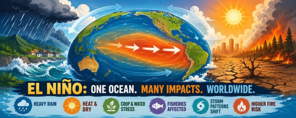
How El Niño Works in Plain English
Under normal conditions, trade winds blow across the tropical Pacific from east to west. These steady winds help push warm surface water toward Indonesia, Papua New Guinea, and northern Australia.
That pile of warm water fuels tropical rainstorms in the western Pacific. Meanwhile, cooler, nutrient-rich water rises from deeper in the ocean near Peru and Ecuador. This process, called upwelling, helps support extremely productive marine ecosystems and major fisheries along South America’s Pacific coast.
During El Niño, those trade winds weaken. Warm surface water spreads back eastward across the Pacific toward Peru and Ecuador. The band of tropical rainstorms shifts with it.
That may sound like a small ocean change, but tropical storms release enormous amounts of heat into the atmosphere. When the usual rain belt moves, it can change wind patterns high above the planet. Those altered wind patterns then influence jet streams, pressure systems, rainfall zones, and seasonal temperatures far from the Pacific.
A useful way to explain it to a kid is this:
El Niño is like moving a giant space heater and thunderstorm factory across the Pacific Ocean. When the heat and rain move, the atmosphere has to reorganize around them.
It is not a remote-control button for world weather. It is more like loading the dice. Some weather outcomes become more likely, but they are never guaranteed.
Why the Pacific Can Affect Places So Far Away
The Pacific Ocean is huge. The tropical Pacific alone stores and moves an incredible amount of heat, moisture, and energy.
When the warmest water and strongest thunderstorms shift eastward during El Niño, the atmosphere responds. The usual circulation of air over the Pacific weakens and changes shape. Scientists call part of this system the Walker circulation—a broad loop of rising, stormy air over warm water and sinking, drier air elsewhere.
As that circulation shifts, it can influence weather patterns far beyond the tropics. That is why a warm patch of ocean near the equator can be connected to drought in Australia, floods in South America, changing hurricane activity in the Atlantic, or unusual winter conditions in parts of North America.
Climate change adds another layer. El Niño is a natural climate pattern, and there is not clear evidence that climate change makes El Niño events happen more often or automatically makes them stronger. But a warmer atmosphere can hold more moisture, warmer oceans contain more energy, and extreme heat begins from a higher baseline. That can make El Niño-related heat, drought, heavy rain, and flooding more damaging when they do occur.
Where El Niño Usually Has Its Biggest Effects
Every El Niño is different. Its impacts depend on timing, strength, other ocean patterns, and random weather variation. Still, some regions have well-known patterns worth watching.
Peru and Ecuador: Warmer Water, Heavy Rain, and Fishing Changes
El Niño got its name from fishers along the coasts of Peru and Ecuador. They noticed that warm ocean water sometimes arrived near Christmas, reducing the cold, nutrient-rich upwelling that normally supports fish populations. They called it El Niño, meaning “the Christ Child.”
During stronger El Niño events, the eastern Pacific can become much warmer than normal. Fish may move, catches can change, and coastal communities can face disruptions. The same warm water can help fuel heavier rainfall along normally dry parts of Peru and Ecuador, increasing the risk of flooding, mudslides, damaged roads, and travel interruptions.
This is one reason El Niño is much more than an abstract weather pattern. In places tied closely to fishing, farming, tourism, or fragile mountain roads, it can affect daily life quickly.
Australia and Indonesia: Higher Risk of Heat, Drought, and Fire
El Niño often shifts tropical rainfall away from Indonesia and northern Australia. That can raise the odds of dry conditions, heat stress, poor crop conditions, and wildfire danger.
This does not mean every El Niño creates catastrophic fires in Australia. Local rainfall, vegetation, wind, land management, and temperature still matter. But El Niño is one of the warning signs that governments, farmers, firefighters, and travellers watch closely.
For travellers, this can mean smoky skies, trail closures, water restrictions, extreme heat advisories, and a higher chance that outdoor plans change quickly.
East Africa, Southern Africa, and Parts of Asia: Rainfall Can Swing Hard
El Niño can affect rainfall patterns across Africa and Asia, but the details vary by season and location.
Parts of East Africa can experience wetter conditions during certain rainy seasons, which may increase flood risk. Meanwhile, southern Africa and parts of South Asia can face drier conditions or changes to monsoon behaviour. These shifts matter because millions of people depend on predictable seasonal rain for food, livestock, hydroelectric power, and drinking water.
A few weeks of missed rain can be inconvenient in a Canadian city. In a place where a family’s crops depend on a short rainy season, it can be life-changing.
Central America, the Caribbean, and Northern South America: Drier Conditions May Become More Likely
El Niño is often linked with drier conditions in Central America, the Caribbean, northern South America, Indonesia, and parts of southern Asia.
That can strain reservoirs, reduce crop yields, increase wildfire danger, and put pressure on hydropower systems. It can also affect travel. Drought can change river levels, reduce water access in rural areas, increase smoke from fires, and make some natural areas less safe or less enjoyable to visit.
The Southern United States: Wetter Winter Odds
In the United States, the clearest El Niño effects often show up during winter rather than summer. A strong El Niño can tilt the odds toward wetter conditions across parts of the southern United States.
That does not guarantee constant rain or flooding. It means the large-scale pattern may favour more storms and precipitation than usual in certain regions. For places already vulnerable to flash flooding or saturated soil, that matters.
El Niño can also reduce the odds of an especially active Atlantic hurricane season because it can increase wind shear—winds at different heights blowing at different speeds or directions. Wind shear can make it harder for hurricanes to organize and strengthen.
What Could El Niño Mean for Canada?
For Canadians, the answer is less dramatic than many online videos make it sound.
Environment and Climate Change Canada’s summer 2026 outlook called for warmer-than-normal temperatures across most of the country. It also said the developing El Niño was expected to take fuller effect later in 2026.
That does not mean Ottawa is guaranteed to have the hottest summer ever. It does not guarantee drought. It does not mean every July or August heatwave is “because of El Niño.”
For Eastern Ontario, a responsible takeaway is:
- Expect the possibility of more hot stretches and take heat warnings seriously.
- Watch for changing wildfire smoke and air-quality conditions.
- Use short-range forecasts for actual plans, work, travel, and family activities.
- Treat a seasonal outlook as a broad probability, not a day-by-day forecast.
Seasonal forecasts are useful for preparation, but they cannot tell you whether a specific family barbecue, camping trip, or workday in August will be rainy, smoky, or dangerously hot. For that, the best source is still Environment Canada’s daily forecast, radar, warnings, and air-quality information.
Is the Current European Heatwave Caused by El Niño?
Not directly—not in a way anyone should state confidently.
Europe is experiencing extraordinary late-June 2026 heat, with temperature records falling across several countries. The World Meteorological Organization says Europe is warming rapidly and that extreme heat is expected to become more frequent, intense, and long-lasting in a changing climate.
El Niño may add warmth to the global climate system over the coming months, but Europe is not one of the regions with the clearest, most dependable direct El Niño effects. WMO notes that El Niño impacts are typically more pronounced in other parts of the world than in Europe.
So the honest answer is:
The developing El Niño may be part of a warmer global background, but Europe’s current heatwave has its own immediate weather causes and should not be casually labelled an “El Niño heatwave.”
That is the difference between explaining weather honestly and chasing a dramatic headline.
How El Niño Shapes History, Landscapes, and Travel
El Niño has always shaped human life, even before people understood the science behind it.
Coastal fishers in Peru noticed its effects long before satellites existed. Farmers learned that rainfall patterns could shift. Communities built around seasonal rivers, fisheries, and monsoons have had to adapt to its unpredictable cycles. Modern cities are more connected than ancient societies, but they are not immune: airports, food prices, hydroelectric power, wildfire smoke, shipping, tourism, and insurance costs can all feel the ripple effects.
For travellers, El Niño is a reminder that “best season to visit” guides are becoming less reliable. A dry destination may suddenly face floods. A popular hiking region may have smoke or water restrictions. A tropical trip may be disrupted by unusual rain, heat, or marine conditions.
That does not mean people should stop travelling. It means smart travel planning should include weather flexibility, travel insurance that covers real disruptions, backup activities, and a habit of checking official local warnings before heading into the outdoors.
The Bottom Line
A potentially very strong El Niño is developing in 2026, and it is a global climate event—not just a North American one.
It begins in the tropical Pacific, but its effects can reach South America, Australia, Indonesia, Africa, Asia, the United States, Canada, and beyond. Some places may become wetter. Others may become drier, hotter, smokier, or more vulnerable to wildfire and crop stress.
But El Niño is not a magic explanation for every hot day or every storm. Think of it as a powerful global influence that shifts the odds, while local weather patterns and human-caused climate warming still shape what people actually experience on the ground.
For Ottawa and much of Canada, the practical move is not panic. It is preparation: pay attention to official heat, smoke, and severe-weather alerts; plan outdoor activities with flexibility; and understand that the world’s weather is more connected than it first appears.
Related External Links
- World Meteorological Organization: Prepare for El Niño — A current global update on the developing 2026 El Niño and its likely worldwide effects.
- Environment and Climate Change Canada: Summer Seasonal Outlook — Canada’s official summer 2026 outlook, including expected temperature patterns and weather risks.