
The Winds With Names: Chinook, Foehn, Sirocco, and the Forces That Shape Entire Regions
Some winds are just weather. Others become part of a place’s identity.
In southern Alberta, a Chinook can turn a bitter winter day into something that feels strangely close to spring. In the Alps, a Foehn can bring warm, dry air down the far side of a mountain range. Across North Africa and the Mediterranean, a Sirocco can carry heat, dust, haze, and eventually heavy humidity into cities hundreds of kilometres from the Sahara.
These winds are not myths or poetic nicknames invented by travellers. They are real regional weather patterns, shaped by mountains, deserts, seas, valleys, and differences in air pressure. They affect roads, snowpack, farming, travel, wildfire risk, architecture, visibility, and even the way people describe life in a region.
Quick Answer: What Are Named Winds?
Named winds are recurring regional wind patterns that are common enough, distinctive enough, or influential enough to become part of local vocabulary. Their names usually describe where they come from, what they do, or the people who have lived with them for generations.
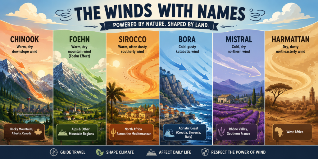
The Chinook, Foehn, and Sirocco are especially interesting because they show three very different ways geography can transform moving air:
- Chinook: A warm, dry wind descending the eastern side of the Rocky Mountains in Canada and the United States.
- Foehn: The broader name for warm, dry winds that descend the sheltered side of mountain ranges, especially associated with the Alps.
- Sirocco: A warm southerly wind that begins over North Africa and crosses the Mediterranean, often arriving in Europe humid and hazy.
A named wind is really a story about land meeting air. Mountains force air upward. Deserts heat it. Seas add moisture. Valleys accelerate it. The result can make one side of a region feel completely different from the other.
Why Winds Get Names in the First Place
People who live with a repeated weather pattern learn to recognize it quickly. They notice its clouds, its smell, the direction it comes from, the way it changes the temperature, and what it means for work or travel that day.
A farmer may notice that one wind dries the soil. A sailor may know it can roughen a particular coastline by afternoon. A mountain town may recognize that a warm downslope wind can melt snow, increase avalanche concerns, or make wildfire conditions worse. Over generations, the wind stops being an abstract forecast symbol and becomes part of local life.
That is why named winds are so interesting for geography. They are not just “air moving from high pressure to low pressure.” They are weather with a home address.
Chinook Country: Alberta’s Sudden Winter Warm-Up
The Chinook is probably Canada’s best-known named wind. It is most strongly associated with the eastern slopes of the Rocky Mountains, especially southern Alberta and communities such as Calgary, Canmore, Lethbridge, Medicine Hat, and the foothills west of the Prairies.
A Chinook is warm, dry, and often dramatic. It can arrive after a cold stretch and raise temperatures quickly, sometimes melting snow so fast that people call it a “snow eater.” The speed of the change is part of what makes it memorable. One day may feel like deep winter; the next may bring bare grass, dripping roofs, and people suddenly walking outside without heavy layers.
How a Chinook Forms
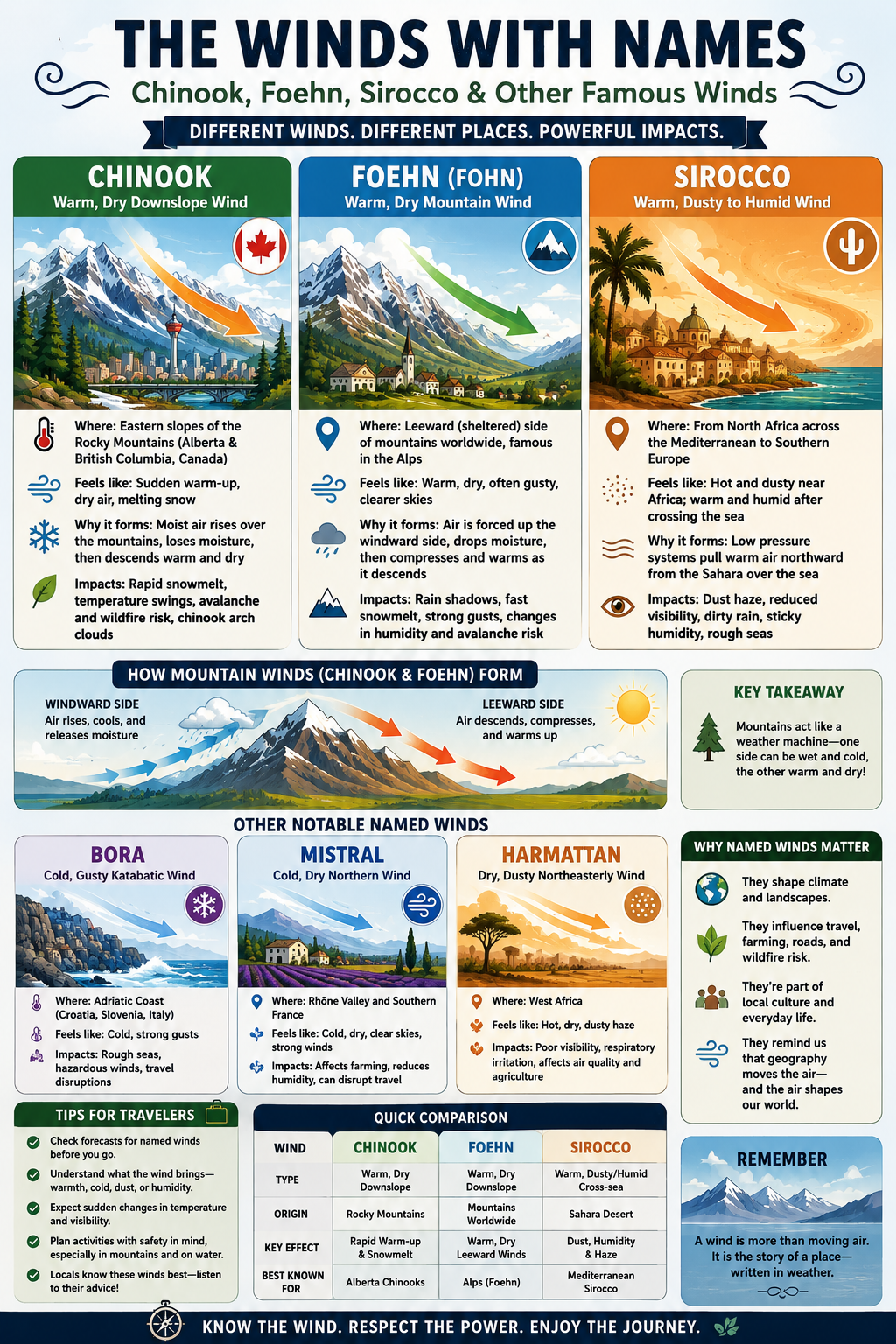
The simplest way to picture a Chinook is to imagine moist air moving east toward the Rocky Mountains. As that air is pushed up the western side of the mountains, it expands and cools. Cooling air cannot hold as much water vapour, so clouds form and moisture may fall as rain or snow.
Once the air passes over the mountains and begins descending the eastern side, it is compressed by increasing air pressure. Compression warms the air, and the moisture loss on the windward side helps leave the descending air relatively dry. By the time it reaches the foothills and Prairies, it can feel much warmer than the surrounding winter air.
The real atmosphere is more complicated than a single textbook diagram. Wind speed, mountain shape, upper-air conditions, cloud cover, and other weather systems all matter. But the basic result is easy to understand: mountains can transform incoming air into a warm, dry wind on their sheltered side.
What a Chinook Changes on the Ground
For people living in Alberta, Chinooks can be welcome after a brutal cold spell. They can reduce heating demand for a day or two, clear some snow, make sidewalks easier to walk, and give wildlife and people a brief break from severe cold.
But a sudden thaw also creates practical problems. Snowmelt can refreeze overnight, turning roads and sidewalks icy. Rapid melting can overload drains or create slushy streets. Strong gusts can make high-profile vehicles harder to control, especially on open highways near the foothills.
Chinooks can also increase fire concerns when landscapes are dry. Warm, dry, gusty air can remove moisture from vegetation quickly. A mild winter day may feel harmless, but wind is one of the biggest factors that can turn a small outdoor fire into something difficult to control.
The Chinook Arch
One of the most recognizable visual signs is the Chinook arch, a long band or bank of cloud that can appear along the eastern side of the Rockies. From the Prairies, it may look like a massive smooth wall of cloud stretching across the sky, with a clearer patch of blue beneath it.
That cloud formation is part of the mountain-wave pattern created as air flows over the Rockies. It is another reminder that weather is three-dimensional. Even when the surface wind feels mild, air high above the mountains may be rising, sinking, folding, and creating large-scale cloud structures.
The Foehn: The Mountain Wind With Many Names
The Foehn is the classic mountain version of this process. The name comes from the Alps, where people have recognized the warm, dry downslope wind for centuries. Today, “Foehn effect” is used more broadly for the weather pattern that happens when air crosses a mountain range and becomes warmer and drier on the leeward side.
The important word is leeward. That means the sheltered or downwind side of a mountain range. The opposite side, where air is forced to rise, is called the windward side. One side may be wet, cloudy, and cool while the other side is sunnier, warmer, and much drier.
This is why mountains can create surprisingly sharp weather differences. You can drive across a mountain pass and move from rain into sunshine, from damp forest to dry grassland, or from deep snow to bare slopes over a relatively short distance.
Why the Foehn Effect Matters
The Foehn effect helps explain rain shadows. A rain shadow is a drier region on the lee side of mountains because much of the moisture fell out of the air before it crossed the range.
This has a major influence on landscapes. Mountain barriers can help create wet forests on one side and dry valleys, grasslands, or semi-arid terrain on the other. The same general process influences places around the world, including parts of North and South America, Europe, Asia, and New Zealand.
Foehn winds can also be powerful. They may bring unusually warm temperatures, fast snowmelt, strong gusts, turbulent flying conditions, or rapid drying. In cold mountain environments, that can affect avalanche conditions, streams, roads, and the stability of snow or ice.
The Chinook is one regional form of the Foehn effect. Other parts of the world have their own names for similar winds. That is part of the fun: the physics may be related, but every landscape gives the wind its own personality.
The Sirocco: A Wind That Crosses the Sahara and the Sea
The Sirocco is almost the opposite kind of travel story. Instead of descending from mountains, it begins over North Africa and moves northward across the Mediterranean.
Near the Sahara, a Sirocco can be hot, dry, and dusty. It may lift fine sand and dust into the atmosphere, reduce visibility, and create a yellow, orange, or hazy sky. The air can feel harsh and dry, especially close to its source region.
But once that same air crosses the Mediterranean Sea, it picks up moisture. By the time it reaches southern Europe, it may be warm and humid rather than dry. That means the Sirocco can feel sticky, oppressive, or stormy in places such as Italy, Malta, Sicily, southern France, and parts of the Balkans.
How the Sirocco Forms
The Sirocco is linked to low-pressure systems moving across the Mediterranean region. Air flows around those systems, drawing warm air northward from North Africa toward the Mediterranean Basin.
The direction matters. A wind coming from the south or southeast can carry the signature of the place it passed over. In the case of the Sirocco, that signature may include desert dust, heat, and then added moisture from the sea.
This is one reason weather can connect distant places. Dust from the Sahara does not stay in the Sahara. Under the right conditions, it can travel across water and appear on cars, windows, snowfields, and outdoor furniture in southern Europe.
What the Sirocco Feels Like
The Sirocco is not always identical. Its character depends on where it begins, how long it travels over water, the strength of the weather system driving it, and what local terrain does to it.
A Sirocco may bring:
- Hot, dusty air near North Africa
- Hazy or reduced-visibility conditions
- Dirty rain when dust mixes with precipitation
- Warm, humid weather along European coasts
- Choppy seas and difficult boating conditions
- A strange yellowish or muted daylight caused by airborne dust
For travellers, this is a good reminder that a forecast temperature alone does not tell the whole story. A warm 24°C day with dry air feels different from 24°C with windblown dust, high humidity, and a low grey sky.
Three More Named Winds Worth Knowing
The world has dozens of named winds, and each one reveals something about its region. You do not need to memorize all of them, but a few examples make the pattern easier to see.
The Bora: A Cold Blast on the Adriatic
The Bora is a cold wind associated with the Adriatic coast, especially Croatia, Slovenia, northeastern Italy, and nearby areas. It often descends from higher inland terrain toward the sea, bringing sharp cold and powerful gusts.
Unlike the warm Chinook, the Bora is known for its coldness. It can make coastal conditions feel much harsher than the forecast temperature suggests. Strong Bora events can affect road travel, ferries, harbour operations, and everyday life in exposed coastal towns.
The Mistral: Southern France’s Cold, Dry Wind
The Mistral is a cold, dry northerly or northwesterly wind associated with southern France and the Rhône Valley. It is shaped by the geography of the valley, which helps channel the wind toward the Mediterranean.
The Mistral is famous for clear skies, dry air, and forceful gusts. It has influenced the way people think about local architecture, farming, travel, and coastal weather. When a wind visits often enough, communities build habits around it.
The Harmattan: Dusty Air Across West Africa
The Harmattan is a dry, dusty wind that blows from the Sahara across parts of West Africa. It can create a haze that reduces visibility and coats surfaces with fine dust.
Like the Sirocco, the Harmattan shows how deserts influence weather far beyond their borders. It also shows why named winds are not just travel trivia. They shape air quality, transportation, agriculture, and daily routines.
How to Read Named Winds When You Travel
You do not need to be a meteorologist to use this information. The goal is simply to understand that a wind’s direction and origin can tell you a lot about the day ahead.
When you see a named wind in a forecast, ask a few simple questions:
- Is it expected to be warm or cold?
- Is it dry, humid, dusty, or stormy?
- Is it coming off mountains, across a desert, or over open water?
- Could it affect driving, boating, hiking, flights, or wildfire conditions?
- Will the temperature feel different because of wind chill, humidity, dust, or sudden gusts?
For mountain trips, pay attention to wind warnings even when the forecast looks mild. A warm Foehn-type wind can still bring strong gusts and fast-changing conditions. For Mediterranean travel, a Sirocco day may be a good time to carry water, protect electronics and eyes from dust, and avoid making plans that depend on perfectly clear views.
For Alberta road trips, a Chinook can be a welcome break from cold weather—but it can also create slush, standing water, changing road conditions, and overnight refreezing. A thaw is not the same thing as stable driving conditions.
The Real Lesson of Named Winds
The most interesting thing about Chinooks, Foehns, and Siroccos is not their vocabulary. It is what they reveal about the world.
Mountains do not just sit on maps; they redirect air, create rain shadows, shape forests, and change temperatures. Deserts do not stay contained inside their borders; their dust and heat can travel across seas. Valleys do not just hold rivers and towns; they can focus wind into a force people learn to respect.
A named wind is proof that weather belongs to place. It is geography in motion.
The next time you hear about a Chinook in Alberta, a Foehn in the Alps, or a Sirocco crossing the Mediterranean, picture the journey of the air itself. It has crossed a mountain wall, risen into cloud, dropped its moisture, rolled down a slope, passed over desert, or gathered water vapour from the sea.
That journey is what gives the wind its name—and gives a region its character.
Related External Links
- Met Office: Winds of the World — A clear guide to the Chinook, Foehn, Sirocco, Bora, Mistral, Harmattan, and other named regional winds.
- NOAA National Weather Service: Chinook Glossary Entry — A concise explanation of Chinook winds and their connection to Foehn winds on the lee side of mountain ranges.