
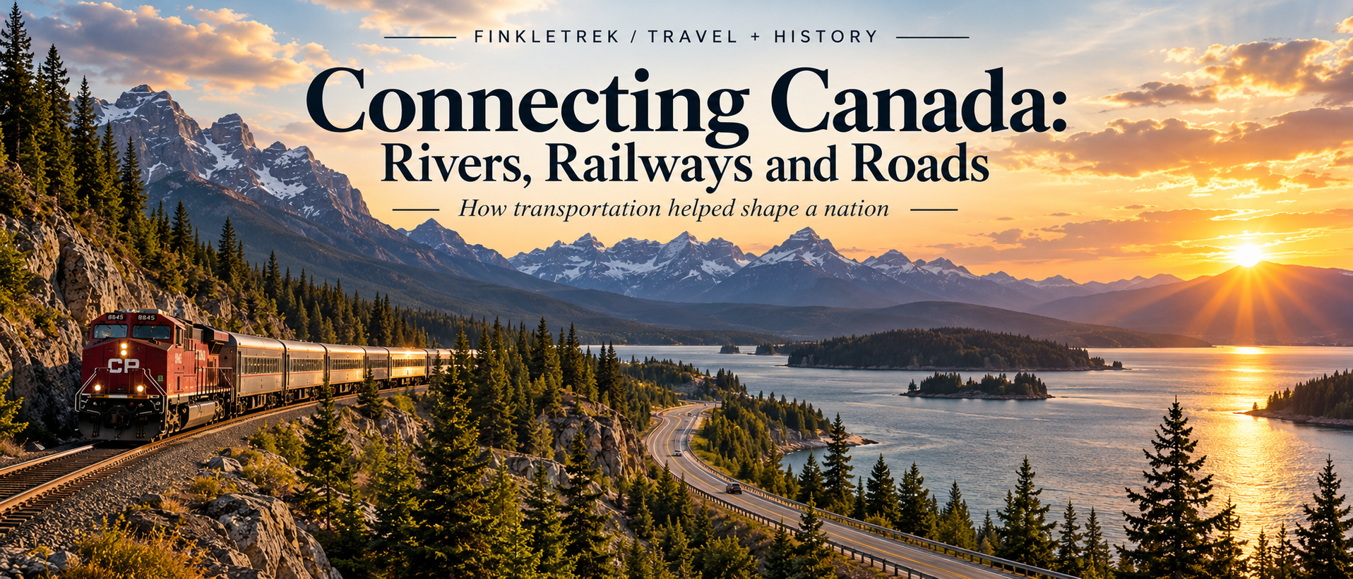
Connecting Canada: How Rivers, Railways, and Roads Shaped a Nation
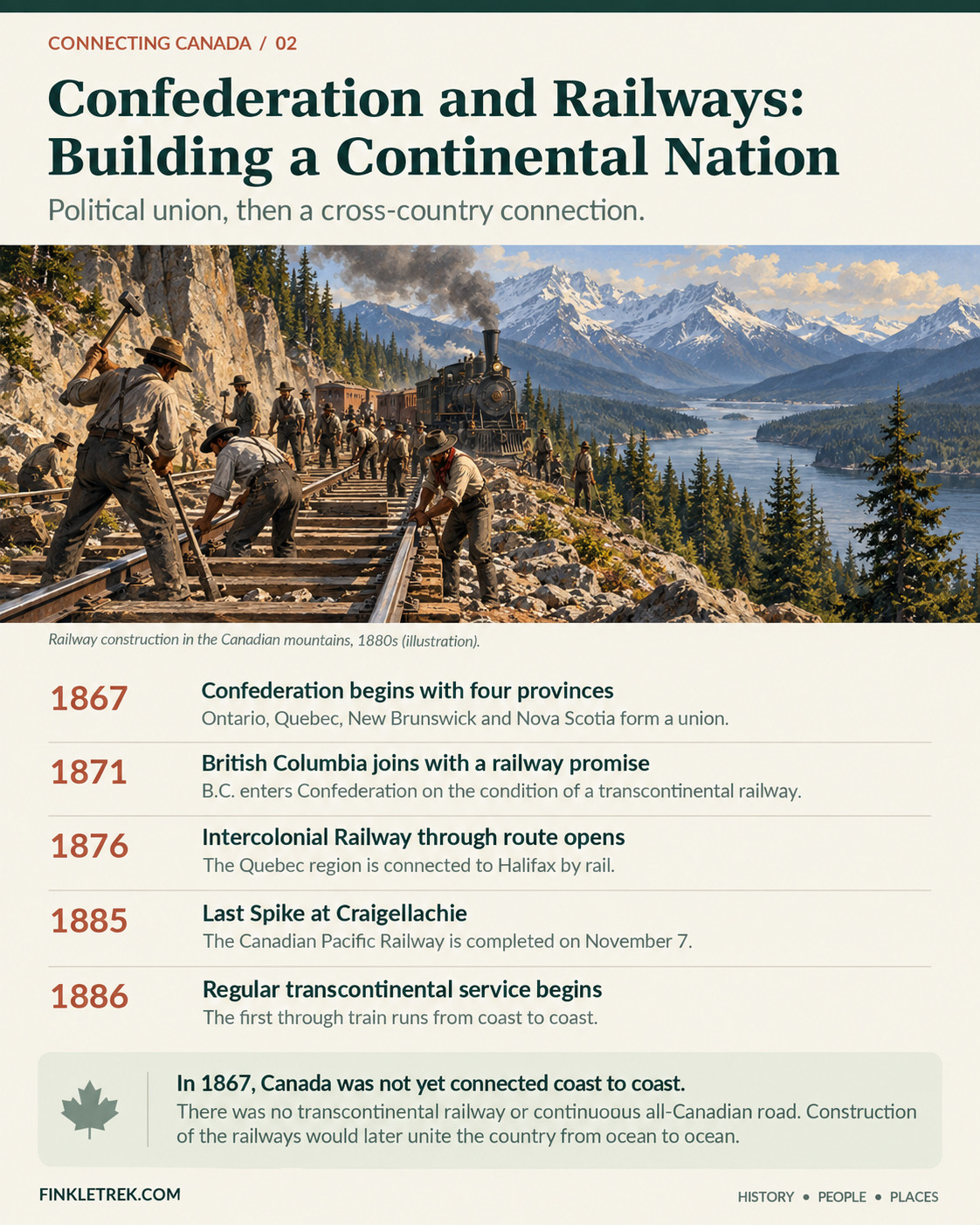
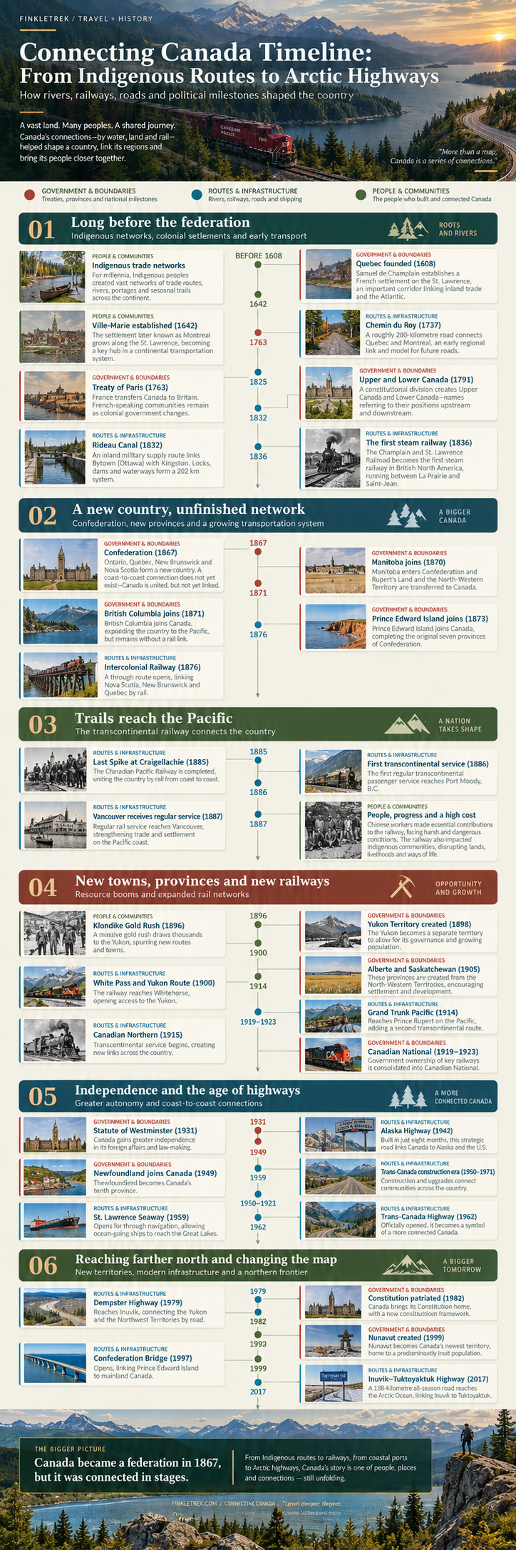
On July 1, 1867, Canada became a country—but not the coast-to-coast country familiar to us today. Its original four provinces occupied only part of the territory that would eventually form the federation, and there was no railway or continuous all-Canadian road connecting the Atlantic and Pacific. Confederation created a political union; turning that union into a country people could cross was another challenge entirely. That work would reshape communities, determine the fortunes of towns, and continue long after the first national railway was completed. Canada
Canada’s history becomes easier to understand when we follow two timelines together: the changing political map and the routes connecting the places on it. Sometimes a transportation project followed a province’s entry into Confederation; sometimes the promise of a connection helped persuade a colony to join. But neither story began with empty land. Long before the Canadian federation existed, Indigenous peoples maintained their own communities, territories, and routes across the continent. Canada
Before Confederation: A Continent Already Connected
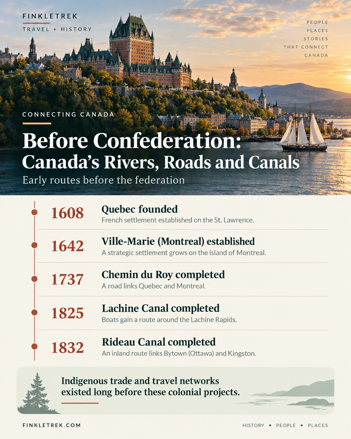
For thousands of years, Indigenous peoples travelled through landscapes that later newcomers would struggle to navigate. Rivers, lakes, portages, and overland trails connected communities and supported trade, diplomacy, and seasonal movement. The Mattawa River in present-day Ontario offers one example: Indigenous peoples used this corridor for more than 6,000 years before it became associated with European fur traders and voyageurs. What later appeared on colonial maps as an exploration route was often already a well-known passage through someone else’s homeland. Ontario Parks
Waterways made movement possible, but travelling them required knowledge: where to land, which rapids could be passed, and where boats and supplies had to be carried overland. European traders and officials relied heavily on Indigenous guides, canoe technology, and established communication networks. In New France, Indigenous couriers also carried letters and news between distant settlements. Canada’s later transportation systems therefore did not create connection from nothing; they overlaid, adapted, and frequently disrupted connections that already existed. Canadian Museum of History
1608–1791: Settlements, Roads, and Changing Empires
The French settlement of Quebec, founded by Samuel de Champlain in 1608, and Ville-Marie, established in 1642 and later known as Montreal, became important centres along the St. Lawrence. Their position beside the river mattered enormously in a world where transporting heavy goods overland was difficult. These were not randomly scattered settlements gradually searching for one another. They developed along a waterway that connected inland trade with the Atlantic, making geography a powerful influence on the emerging colonial economy. Canada
A major overland improvement arrived in 1737 with the completion of the Chemin du Roy between Quebec and Montreal. Stretching roughly 280 kilometres, the road linked communities along the north shore of the St. Lawrence and provided a route for wheeled traffic between the two centres. It was a substantial achievement, but it should not be imagined as a modern highway. This was a road through settled parishes, connecting a particular colonial region—not the beginning of an uninterrupted roadway to the Pacific. Le Chemin du Roy
Political control changed after Britain defeated France in the struggle for its North American colonies. The Treaty of Paris in 1763 transferred Canada from French to British rule, although French-speaking communities and institutions remained. In 1791, the territory was divided into Upper Canada and Lower Canada, broadly corresponding to the southern portions of present-day Ontario and Quebec. Those names described their positions along the St. Lawrence system: Upper Canada lay farther upstream, not farther north. Canada
1825–1832: Canals Changed What the Rivers Could Do
Rivers were valuable transportation corridors, but rapids could interrupt a journey as effectively as a missing section of road. The Lachine Canal, completed in 1825 after construction began in 1821, helped overcome that problem at Montreal. Its approximately 14-kilometre route connected the port with Lake Saint-Louis, bypassing the Lachine Rapids through a series of locks. Rather than abandoning water transportation, builders were improving it, making Montreal a stronger link between Atlantic shipping and the interior. Parks Canada
The Rideau Canal followed in 1832, creating a roughly 202-kilometre inland connection between the Ottawa River and Lake Ontario at Kingston. Its military purpose was central: British authorities wanted a supply route less exposed to attack from the United States than the St. Lawrence corridor. Construction combined excavated channels, locks, dams, and existing rivers and lakes into a navigable system. The canal linked Kingston with the settlement known as Bytown, later Ottawa, decades before either city belonged to a Canadian federation. UNESCO World Heritage Centre
1836–1859: Railways Began by Connecting Existing Routes
Canada’s first steam railway opened in 1836, and its modest length reveals how early railway builders thought. The Champlain and St. Lawrence Railroad ran approximately 23 kilometres between La Prairie, near Montreal, and Saint-Jean on the Richelieu River. It connected waterways, providing a shortcut within the broader Montreal–New York transportation corridor. The first railway was therefore not conceived as a transcontinental line; it was a practical way to improve one difficult section of an existing journey. Parks Canada
The scale increased dramatically during the following two decades. On October 27, 1856, regular Grand Trunk Railway service connected Toronto and Montreal, with communities including Kingston and Brockville along the route. By 1859, the railway extended west to the Sarnia area, while Montreal’s Victoria Bridge provided a major crossing of the St. Lawrence. A substantial railway network was developing before Confederation, but it remained concentrated in particular regions rather than stretching across the future country. Queen’s University Digital Collections
1862–1865: A Wagon Road Into the Cariboo
While railways expanded in the east, a different transportation challenge occupied the colony of British Columbia. Gold discoveries drew people into the interior, where supplying mining communities was difficult and expensive. Between 1862 and 1865, the Cariboo Wagon Road was constructed from Yale, at the head of steamboat navigation on the lower Fraser River, toward the goldfields around Barkerville. Its route climbed through demanding terrain to connect river transportation with an inland mining economy. Parks Canada
The road carried more than prospectors’ ambitions. Colonial authorities wanted to reduce transportation costs and direct commerce through British Columbia rather than competing American routes. Barkerville’s importance and Yale’s role as a transportation gateway were tied to those economic decisions. This is an early example of a pattern repeated across Canada: roads did not simply follow settlement; their placement helped determine where trade, investment, and settlement would concentrate. Parks Canada
1864–1867: Creating the Federation
By the 1860s, the political arrangement in central Canada had changed again. Upper and Lower Canada had been united in 1841 as the Province of Canada, with Canada West and Canada East forming its two main sections. Between 1864 and 1867, political leaders from that province, New Brunswick, and Nova Scotia negotiated a larger union with the British government. Their solution was a federation: a national government alongside provincial governments, rather than one legislature governing everything. Canada
The British North America Act brought that federation into existence on July 1, 1867. The Province of Canada was divided into Ontario and Quebec, which joined New Brunswick and Nova Scotia as the four founding provinces. John A. Macdonald became the first prime minister, with figures including George-Étienne Cartier playing central roles in the negotiations. Confederation established a new system of government, but it did not instantly produce Canada’s modern borders or complete independence from Britain. Canada
So what could someone actually travel between in 1867? Montreal, Kingston, Toronto, and the Sarnia area were already connected by the Grand Trunk system, while other regions had their own roads, waterways, and railway sections. But the through railway linking the Quebec region with Halifax was still unfinished, and no railway crossed the continent to British Columbia. There was also no continuous all-Canadian east–west road: the transportation map was a collection of regional networks, gaps, and transfers rather than one national route. TRHA
1869–1873: The Map Expanded Faster Than the Connections
Canada’s westward expansion was neither an empty-land transaction nor an uncontested transfer. During the Red River Resistance of 1869–1870, Métis people opposed arrangements to transfer their homeland without their consent and formed a provisional government associated with Louis Riel. Negotiations helped produce the Manitoba Act, and Manitoba became Canada’s fifth province on July 15, 1870. Its entry was therefore shaped by Métis political action, not simply by officials in Ottawa drawing a new provincial boundary. Indigenous Peoples Atlas of Canada
In 1870, Canada also acquired Rupert’s Land and the North-Western Territory, vastly enlarging the federation’s claimed territory. Outside the small new province of Manitoba, much of this area became the Northwest Territories. The transportation problem remained enormous, however, and the Dawson Route, completed in 1871, illustrates the limitations. Connecting Lake Superior with the Red River region, it combined roads and waterways rather than providing a continuous wagon road or railway from eastern Canada to Winnipeg. Canada
British Columbia joined on July 20, 1871, bringing the federation to the Pacific. The colony itself had already undergone changes: Vancouver Island and mainland British Columbia had been separate colonies before being united in 1866. A promised railway connection with eastern Canada was a crucial condition of Confederation. Canada now possessed an Atlantic-to-Pacific political footprint, but the railway intended to make that union practical still had to be built across the intervening territory. Canada
Prince Edward Island joined in 1873, and transportation again helped shape the decision. Construction of the island’s railway, undertaken between 1871 and 1875, created debts that its small colonial government struggled to carry. Financial difficulties associated with the project became an important factor in accepting Confederation. British Columbia sought a railway connection as part of joining Canada; Prince Edward Island’s costly railway helped push it toward joining, showing how infrastructure and politics could become inseparable. Parks Canada
1876: Connecting the Original Provinces by Rail
Before celebrating the railway to the Pacific, it is worth looking east. In 1876, the Intercolonial Railway’s through route officially opened between the Quebec region and Halifax, connecting existing railway sections with new construction through New Brunswick and Nova Scotia. The project fulfilled a major Confederation commitment and improved access to Atlantic ports during the season when ice restricted St. Lawrence navigation. Places along the route gained stronger links to larger markets, while the original provinces became more closely connected overland. The railway helped make the federation function as a connected economy, not merely a constitutional agreement. Canada
1881–1884: Building West—and Building Towns
The Canadian Pacific project did not begin with one uninterrupted burst of construction. Surveys, government-built sections, political disputes, and changes in management preceded the incorporation of the Canadian Pacific Railway company in 1881. The company took over an undertaking already partly advanced and pushed to close the remaining gaps. Those gaps included both mountain terrain in British Columbia and difficult country across the Canadian Shield north of Lake Superior; the most formidable obstacles were not all in the Rockies. TRHA
Regina shows how railway decisions could help create a new urban centre. A settler community developed there in 1882 beside the approaching railway, in a place already known to Indigenous peoples as Oskanakâ-asastêki, or “pile of bones.” Regina became the capital of the Northwest Territories in 1883 and was incorporated as a town that December. Its selection was entangled with political influence and land speculation, including Lieutenant-Governor Edgar Dewdney’s interests, demonstrating that a railway town’s location was not always the obvious or inevitable choice. City of Regina
Even in 1884, a westbound journey could require several different forms of transportation. One route involved taking a train from Toronto to Owen Sound, boarding a steamship across the Great Lakes to Port Arthur, and continuing by rail toward Winnipeg. The arrangement worked around the unfinished railway north of Lake Superior. It is a useful snapshot of Canada in transition: important sections existed, but travellers still had to stitch them together into a complete journey. TRHA
1885–1887: The First Transcontinental Railway
On November 7, 1885, the Last Spike was driven at Craigellachie, near Eagle Pass in British Columbia. The ceremony marked the completion of the Canadian Pacific Railway’s transcontinental construction connection, but regular passenger service was a separate milestone. The first scheduled transcontinental passenger train from Montreal reached Port Moody on July 4, 1886. The distinction matters: joining the rails made the route physically possible, while operating a dependable service required equipment, organization, maintenance, and further work. Parks Canada
Port Moody was the initial Pacific terminus, but the railway soon helped redirect growth toward Vancouver. Incorporated in 1886, Vancouver received its first Canadian Pacific passenger train in May 1887, strengthening its position as the railway’s coastal gateway. Its development illustrates the influence of a terminal: passengers and goods arriving at the end of a continental route needed somewhere to transfer, trade, and continue by sea. Railway geography was becoming urban geography, helping shape the future importance of the city. Wikipedia
Completion did not mean that the mountains had been conquered permanently. At Rogers Pass in the Selkirks, deep snow and avalanches made operating the railway extremely difficult, and trains stopped running for months during the first winter of 1886–1887. Builders added snowsheds, while railway crews used specialized equipment and extra locomotives to manage the route. The celebrated connection was therefore not a finished object that could simply be left alone; it was a demanding system that had to be kept functioning. Parks Canada
The human cost also belongs in the story. Approximately 15,000 Chinese workers were brought into the British Columbia construction effort, where dangerous tasks, harsh conditions, disease, and inadequate care killed hundreds. Their contribution was essential, yet Canada imposed a head tax on Chinese immigration in 1885, the year the railway was completed. The contrast is stark: workers helped create a national connection while facing policies that restricted their own opportunities to build lives in the country. Canada
For many Indigenous communities, railway expansion accompanied dispossession rather than shared prosperity. Tracks crossed Indigenous territories, while government settlement policies displaced people and constrained their use of ancestral lands. The same railway that carried newcomers toward new opportunities also enabled the expansion of colonial control. Recognizing that history does not erase the engineering achievement; it explains why the achievement cannot honestly be told only through the viewpoint of railway executives, politicians, and arriving settlers. Canada
1896–1905: Gold Rushes, Immigration, and New Centres
The next great northern surge followed the discovery of gold on Bonanza Creek in 1896. News spread internationally in 1897, drawing a rush of people toward the Klondike and Dawson. Many approached through the Alaskan ports of Skagway and Dyea, then faced mountain crossings and a long journey through lakes and along the Yukon River. As with earlier gold rushes, the discovery mattered—but so did the difficult question of how to reach it with enough supplies to survive. White Pass & Yukon Route
The rush helped prompt the creation of Yukon as a separate territory in 1898. That year, construction began on the White Pass and Yukon Route railway, which connected Skagway with Whitehorse when completed in 1900. Whitehorse became an important point where railway travel met the Yukon River transportation system. This was not an extension of the Canadian Pacific line: northern access developed through a separate corridor reaching a Pacific port in Alaska, rather than simply continuing north from a southern Canadian railway. Canada
Meanwhile, immigration to the Prairies accelerated, particularly from 1896 to 1914. Railways carried settlers inland and provided access to equipment, building materials, and markets for agricultural production. The Dominion Lands Act of 1872 had offered qualifying settlers 160-acre homesteads under conditions requiring settlement and improvement, helping establish the framework for that expansion. This policy promoted farming settlement on land already inhabited and used by Indigenous peoples, linking the growth of new communities with the displacement of existing ones. Pier 21
Winnipeg’s growth captured the scale of the transformation: its population rose from about 20,000 in 1886 to roughly 150,000 in 1911. The city became a major gateway through which people and goods moved into the West. In 1905, Alberta and Saskatchewan were created from parts of the Northwest Territories, giving the growing Prairie region two new provincial governments. The western map was becoming more recognizable, but its settlement pattern had been shaped by railway routes, land policies, immigration, and the communities already there. Pier 21
1880–1923: Northern Boundaries and More Transcontinental Lines
Canada’s northern outline also developed in stages. Britain transferred its remaining Arctic possessions to Canada in 1880, while later boundary changes enlarged several provinces. In 1912, Manitoba, Ontario, and Quebec extended northward toward their modern configurations, reaching Hudson Bay or Hudson Strait. These changes are important when reading historical maps: a province might acquire a much larger northern territory without a railway or road immediately reaching through that territory. Political jurisdiction and practical access remained different things. Canada
The Canadian Pacific did not remain the country’s only transcontinental railway. The Grand Trunk Pacific completed its line to Prince Rupert in 1914, following a more northerly western route through Edmonton and the Yellowhead Pass. The Canadian Northern also completed its transcontinental connection in 1915, with Toronto–Vancouver passenger service beginning that November. These lines strengthened different corridors and coastal gateways, spreading railway development beyond the route associated with Regina, Calgary, and the Canadian Pacific. TRHA
More track, however, did not automatically mean sustainable profits. Heavy construction costs and financial pressures, intensified during the First World War, contributed to railway failures and government takeovers. Canadian National emerged through consolidation, with its Crown corporation established in 1919 and the Grand Trunk incorporated into the system in 1923. Canada’s railway map was therefore shaped not only by surveying and construction, but also by debt, competition, and decisions about which essential connections governments would preserve. TRHA
1931–1949: Greater Independence and a Wartime Road North
While transportation networks expanded, Canada’s constitutional relationship with Britain continued to change. The Statute of Westminster in 1931 was a major milestone in Canada’s legislative independence and control over its foreign affairs. This is why 1867 should be understood as the founding of the federation rather than the single moment when every British constitutional connection ended. Canada’s political development, like its transportation development, proceeded through stages rather than one final, all-encompassing event. Canada
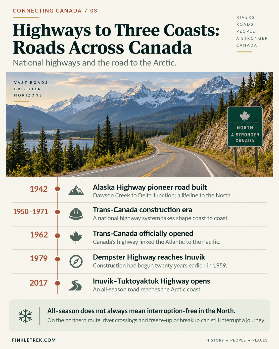
The Second World War produced one of the most dramatic northern construction projects. In 1942, the United States Army Corps of Engineers built the pioneer Alaska Highway from Dawson Creek in British Columbia through Yukon to Delta Junction in Alaska, with vital guidance from local First Nations. The initial road was constructed in approximately nine months, but substantial improvement followed before it became a civilian route. It opened officially to civilian travel in 1948, creating a major overland connection through territory that had already been part of Canada for decades. Canada
Newfoundland entered Confederation on March 31, 1949, becoming the tenth province after two referendums in 1948. It brought its own long history, communities, and institutions into Canada rather than representing a newly settled extension of the mainland. Its entry also underlined the limits of thinking about national connection solely as a road on solid ground. A federation including large islands required marine links as well as land routes, and political union did not make those waters disappear. Canada
1950–1971: The Trans-Canada Highway Era
Construction under the Trans-Canada Highway program began in 1950 through federal–provincial cost sharing. The highway was officially opened in 1962, although work under the original construction program continued until 1971. Those dates describe different milestones, not a contradiction: a ceremonial opening did not mean every section had reached its final standard. The project provided a national framework for road travel, while subsequent widening, reconstruction, and additional route designations continued to change the network. Transport Canada
Water transportation was also being transformed rather than left behind. Construction of the modern St. Lawrence Seaway began in 1954, and the first through transit took place on April 25, 1959, before the ceremonial opening that June. New locks between Montreal and Lake Ontario, working with the Welland Canal system, allowed ocean-going vessels to reach farther into the Great Lakes. Nearly a century after Confederation, Canada was still improving the water corridor that had shaped so much of its early development. Great Lakes St. Lawrence Seaway System
The Trans-Canada became a network, not one uniform highway. Its main western route passed through Winnipeg, Regina, Calgary, and Banff, while the Yellowhead route, officially opened in 1970, linked communities including Saskatoon, Edmonton, Jasper, Prince George, and Prince Rupert. Ferry connections remained necessary for journeys involving Newfoundland and Vancouver Island. For motorists, “crossing Canada” now meant navigating a connected system of highways and crossings, rather than following a single unbroken strip of pavement between the oceans. Transport Canada
1959–1982: The Dempster Highway and a Different Northern Challenge
Farther north, road construction followed another timeline. Work on the Dempster Highway began in 1959, but the route to Inuvik was not completed until 1979. Starting near Dawson City, it crossed mountain and tundra landscapes before reaching the Mackenzie Delta region. It passed through the traditional territories of the Hän, Gwich’in, and Inuvialuit, bringing a southern road connection into places with their own much older histories of movement and settlement. Yukon
Northern engineering introduced problems that could not be solved simply by copying a southern highway. Road construction had to account for permafrost, including the need to protect frozen ground beneath the roadway. Major river crossings added another complication: ferries and winter ice crossings created seasonal interruptions during freeze-up and breakup. An all-season road could therefore be a major improvement without guaranteeing uninterrupted travel every day of the year—a reminder that the word “connected” always needs some explanation. Yukon
In 1982, another constitutional milestone arrived with the patriation of Canada’s Constitution. Canada gained its domestic constitutional amendment arrangements, ending the remaining need to request amendments from Britain. This belonged to a different timeline from highway construction, but both help explain the country’s development. Confederation, independence, territorial boundaries, and transportation connections were related processes, not interchangeable events with one shared completion date. Canada
1997–1999: A Fixed Link in the East and a New Territory
On May 31, 1997, the Confederation Bridge opened between Prince Edward Island and New Brunswick. The 12.9-kilometre crossing replaced the ferry service on that particular route with a fixed road connection after years of debate about its economic and social consequences. For an island that had joined Confederation in 1873, a bridge to the mainland arrived more than a century later. It was another clear example of the distance between becoming politically connected and gaining a particular kind of transportation access. Confederation Bridge
On April 1, 1999, Nunavut was created from the eastern portion of the Northwest Territories. Its establishment followed the 1993 Nunavut Agreement and represented a major achievement in Inuit efforts to shape government and protect rights in their homeland. Unlike the acquisition of a new colony, this was a reorganization within Canada that recognized a distinct political future for the region. The national map changed again, but the meaning of that change lay in governance and self-determination, not in a newly completed highway. Canada
2017: The Road Reached the Arctic Coast
The opening of the Inuvik–Tuktoyaktuk Highway on November 15, 2017, added another striking milestone. The approximately 138-kilometre road connected Inuvik with Tuktoyaktuk, providing an all-season public road connection from Canada’s highway network to the Arctic coast. It replaced a seasonal winter-road connection between the two communities and required years of construction adapted to permafrost conditions. Tuktoyaktuk had not suddenly become connected to the world for the first time, but the new highway changed the kind of overland access available. Government of Northwest Territories
That distinction brings the larger history into focus. The Chemin du Roy, the Rideau Canal, the transcontinental railways, and the northern highways each solved particular transportation problems rather than completing Canada once and for all. Their value lay in what they allowed people to do: move supplies, reach markets, visit family, establish businesses, or make journeys that had previously demanded more complicated arrangements. Their consequences also depended on whose land they crossed and whose priorities guided their construction. Le Chemin du Roy
A Country Connected in Stages
Canada began as a federation in 1867, but understanding its formation requires looking both backward and forward from that date. Indigenous networks and colonial waterways came first; expanding provinces, railway promises, and transcontinental construction followed; highways and new northern connections arrived through the twentieth century and beyond. There was no single moment when the map, the government, and the transportation system all became complete together. The country took shape through successive connections—and through arguments over what those connections should mean. Ontario Parks
Seen this way, travelling through Canada becomes an opportunity to read its history in the landscape. A canal lock, a railway station, a mountain pass, or a bridge can reveal the problem an earlier generation was trying to solve. The most revealing question is not simply when a route was built, but why it went there, who built it, and what changed when it opened. Follow those questions across the map, and the story of connecting Canada becomes the story of how the country itself was made.