
The Northwest Passage: The Arctic Shortcut That Killed Explorers, Defeated a Supertanker, and Could Reshape World Trade
For centuries, the Northwest Passage was one of geography’s great promises. Somewhere beyond the Atlantic, explorers believed, there had to be a navigable route through the frozen islands north of Canada that would emerge into the Pacific. Find it, and ships travelling between Europe, North America and Asia might avoid enormous detours around continents. The prize was so tempting that generations of sailors kept going north even after the Arctic repeatedly demonstrated just how badly it could punish them.
Some expeditions returned with new maps but no passage. Others became trapped for years. Men starved, froze, disappeared, mutinied against their commanders and, in the most infamous expedition of all, appear to have resorted to cannibalism in a desperate attempt to survive. Eventually the route was crossed, but even that achievement did not create the commercial highway Europeans had imagined.
Then, in 1969, the enormous American supertanker Manhattan arrived to test whether modern engineering had finally conquered the same ice that had defeated wooden sailing ships. It had not. Today, however, climate change is altering the Canadian Arctic so dramatically that the Northwest Passage is again being discussed as a potential international shipping route. That raises a remarkable question: after nearly five centuries of failed attempts to tame this place, could the Northwest Passage finally become the shortcut explorers were looking for?
What Exactly Is the Northwest Passage?
The Northwest Passage is not a single narrow channel like the Panama Canal. It is a network of straits, sounds and channels winding through the Canadian Arctic Archipelago between Baffin Bay in the east and the Beaufort Sea in the west. Thousands of islands fragment the region, producing several possible routes between the Atlantic and Pacific.
That geography is part of what made the passage so difficult to understand. An explorer could sail hundreds of kilometres west only to discover that a promising channel ended in land, shallow water or seemingly permanent ice. Even after much of the coastline had been mapped, knowing that a route theoretically existed was very different from being able to sail through it.
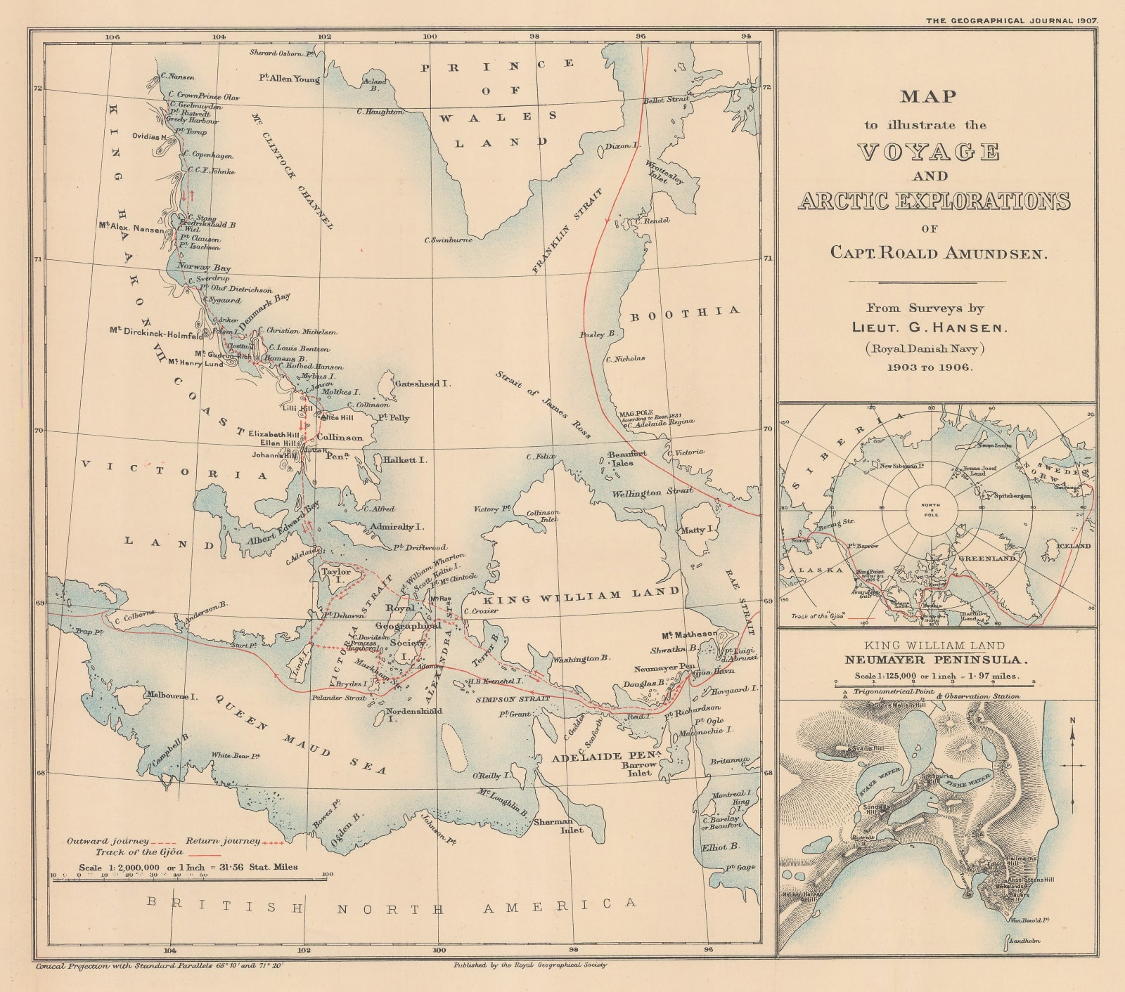
Modern charts make the maze much easier to understand. Lancaster Sound provides the great eastern gateway, while routes then divide through waterways such as Barrow Strait, Peel Sound, Victoria Strait, Simpson Strait, Prince of Wales Strait and McClure Strait. The deeper northern route through Parry Channel is particularly interesting to commercial shipping, but historically it has also been vulnerable to some of the Arctic’s most dangerous multiyear ice.
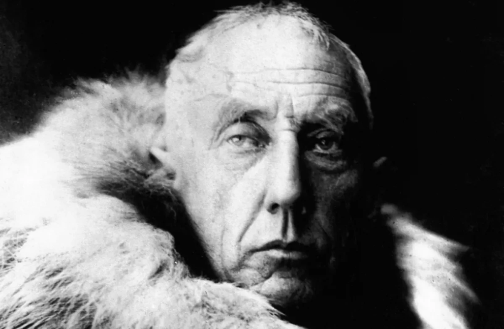
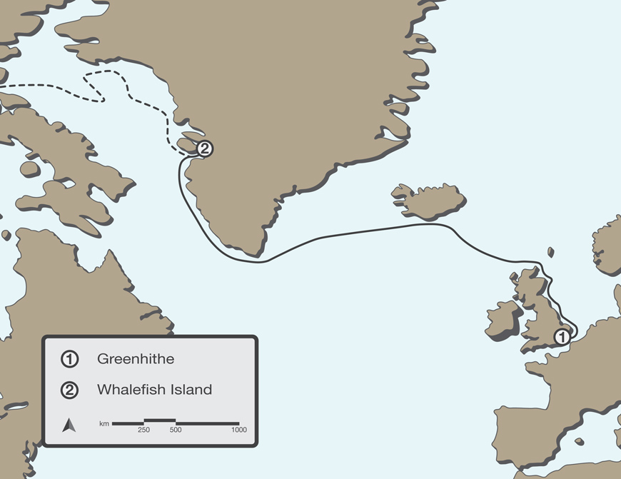
These historical images show three very different eras of the Northwest Passage: the mapped Arctic explored by nineteenth-century expeditions, Roald Amundsen’s age of small-vessel exploration, and the industrial experiment represented by the Manhattan.
The important thing to remember is that this was never an empty wilderness waiting for Europeans to discover it. Inuit and other Indigenous peoples had lived, travelled, hunted and survived throughout the Arctic for generations. Ironically, European expeditions that learned from Indigenous clothing, transportation, hunting and survival practices often performed much better than expeditions that attempted to impose European methods on the environment.
The Obsession With Finding a Northern Shortcut
European interest in a Northwest Passage intensified during the age of exploration because the economic logic seemed irresistible. Maritime powers wanted a shorter route to Asian markets, and maps of northern North America contained enormous blank spaces. If a navigable sea corridor existed through those spaces, whoever mastered it could possess a tremendous commercial advantage.
Martin Frobisher made three voyages beginning in 1576. Instead of discovering the passage, he entered what is now Frobisher Bay on Baffin Island. His expeditions then became distracted by rocks believed to contain gold, resulting in ships returning to England with huge quantities of essentially worthless ore. John Davis followed in the 1580s, exploring Cumberland Sound and the waterway now called Davis Strait, but ice again prevented a breakthrough.
Henry Hudson’s 1610 expedition ended much more darkly. Hudson sailed through the strait that now bears his name and entered Hudson Bay, believing he might finally have found a western sea route. His ship, Discovery, became frozen in during the winter. When spring arrived, Hudson wanted to continue searching instead of immediately returning home.
His exhausted crew had had enough. On June 23, 1611, mutineers placed Hudson, his teenage son and several loyal or sick crew members into a small open boat and abandoned them in the Canadian Arctic. They were never seen again.
The pattern was becoming familiar: every apparent breakthrough simply revealed another obstacle.
Franklin and the Expedition That Vanished
No Northwest Passage story is complete without Sir John Franklin.
In May 1845, Franklin left England commanding HMS Erebus and HMS Terror. These were not fragile vessels sent blindly into dangerous waters. They were strongly constructed former bomb ships, reinforced for Arctic service, equipped with auxiliary steam power and stocked with years of provisions. By the standards of the Royal Navy, Franklin was leading one of the best-equipped Arctic expeditions ever attempted.
After several men were sent home from Greenland, 129 officers and crew continued into the Arctic. They wintered at Beechey Island in 1845–46, where three crewmen died and were buried. The ships then moved south before becoming trapped in ice near King William Island in September 1846.
And then they disappeared.
For years, Britain had no idea what had happened. Search expeditions eventually found evidence at Beechey Island, but the crucial clue did not emerge until a note was discovered in a cairn near Victory Point on King William Island. It revealed that Franklin had died on June 11, 1847. By April 1848, 24 men were dead, and the 105 survivors had abandoned both ships after roughly a year and a half trapped in the ice. Their intention was to travel south toward the Back River and, somehow, reach safety.
None survived.
What happened during that retreat remains one of the darkest stories in Arctic exploration. Bodies, bones, abandoned equipment and personal belongings were eventually found along portions of the route. Inuit witnesses described starving men travelling south and later reported evidence that some had resorted to cannibalism. British society initially reacted with outrage, and explorer John Rae was heavily criticized after reporting the Inuit accounts in 1854.
Modern archaeology has made the story harder to dismiss. Human remains associated with the expedition have shown cut marks consistent with the processing of bodies, supporting the conclusion that at least some Franklin survivors resorted to cannibalism during the final catastrophe. Even Captain James Fitzjames, one of the expedition’s most senior officers, was identified through DNA in research published in 2024 from remains bearing evidence connected to cannibalism.
The exact combination of forces that destroyed Franklin’s expedition is still debated. Starvation, scurvy, disease, exhaustion, lead exposure, severe weather and poor strategic decisions may all have contributed. What is certain is that two sophisticated ships and 129 men entered the Canadian Arctic, and not one returned alive.
The Arctic Knowledge Europeans Almost Ignored
One of the most revealing parts of the Franklin story occurred after Franklin was already dead.
Inuit accounts contained remarkably useful information about where his men had travelled and where the ships had ended up. Yet nineteenth-century British society frequently treated Indigenous testimony with suspicion. Charles Dickens even attacked the credibility of Inuit witnesses after John Rae reported what they had told him about the starving sailors.
More than 150 years later, those oral histories became extraordinarily important.
Parks Canada eventually located HMS Erebus in 2014 and HMS Terror in 2016. Inuit knowledge and oral testimony were crucial in narrowing the search areas. HMS Terror was ultimately found in Terror Bay off King William Island, while Erebus was discovered farther south.
There is a certain historical justice in that. The people whose knowledge had once been dismissed helped solve one of the greatest mysteries in the history of exploration.
Robert McClure Found the Passage — But Couldn’t Sail Through It
Franklin’s disappearance triggered an enormous series of rescue expeditions, and those searches ironically helped finish the work of mapping the Northwest Passage.
One of the most important involved Captain Robert McClure and HMS Investigator. McClure entered the Arctic from the Pacific in 1850 while searching for Franklin. He sailed east through the Bering Strait and explored Prince of Wales Strait between Banks and Victoria islands.
Ice stopped him.
McClure later tried approaching around the northern side of Banks Island. Once again the ice took control. Investigator became trapped at Mercy Bay, and the crew eventually spent almost two years immobilized there as food supplies deteriorated. Several men died, and the remainder faced increasingly serious malnutrition.
A rescue party finally reached them after finding a message McClure’s men had left behind. Investigator was abandoned, and the survivors crossed sections of the Arctic by sledge and eventually travelled home aboard other vessels.
McClure and his expedition therefore helped establish the existence of a complete Northwest Passage, connecting previously explored waterways from the Pacific and Atlantic sides. But they had not sailed one vessel through it. Part of their crossing had been made on foot across the ice.
The great commercial dream remained unfulfilled.
The Places Where Arctic Exploration Went Wrong
A few locations repeatedly appear in the history of the Northwest Passage, and knowing them makes the story much easier to follow:
- Beechey Island: Franklin’s winter camp of 1845–46 and the location of three famous expedition graves.
- King William Island: The centre of the Franklin disaster and the route followed by many of the survivors after abandoning their ships.
- Victoria Strait: The region where Erebus and Terror became trapped in ice in 1846.
- Mercy Bay, Banks Island: Where McClure’s HMS Investigator became imprisoned by ice and was eventually abandoned.
- Gjøa Haven: The protected harbour where Roald Amundsen spent two winters during his successful expedition.
- Simpson Strait: Part of Amundsen’s shallow southern route around King William Island.
- McClure Strait: A potentially valuable deep-water route that remained a formidable ice barrier even for the heavily modified Manhattan in 1969.
- Prince of Wales Strait: The route the Manhattan ultimately used after McClure Strait proved impassable.
Roald Amundsen Finally Does It
The explorer who finally completed the Northwest Passage by ship did not arrive with a gigantic naval expedition.
Roald Amundsen left Norway in 1903 aboard the Gjøa, a vessel of only about 47 tonnes, accompanied by six men. Compared with Franklin’s expedition, it was tiny. That was partly the point. Amundsen had studied previous Arctic failures and chose a vessel capable of navigating shallow and confined waters where larger ships could not go.
He travelled through Lancaster Sound, past Beechey Island and toward King William Island before finding a sheltered harbour. The expedition remained there for two winters while conducting magnetic and meteorological research. The settlement that eventually developed there became known as Gjoa Haven after Amundsen’s ship.
Amundsen also spent time learning from Netsilik Inuit. Indigenous knowledge influenced his use of fur clothing, dog sleds and Arctic survival techniques. Those lessons later became important when he defeated Robert Falcon Scott in the race to the South Pole.
In August 1905, Gjøa left its harbour and continued west through Simpson Strait and the maze of shallow channels beyond. The voyage was dangerous enough that crew members continually measured the depth beneath the keel. In some areas the water was so shallow that a large commercial vessel could never have followed the same route.
Eventually Amundsen encountered a vessel arriving from the Pacific side.
The geographic puzzle was solved.
Ice forced Gjøa to spend another winter near Herschel Island, but the ship finally reached Nome, Alaska, on August 31, 1906. After centuries of speculation, failed expeditions and deaths, one small Norwegian vessel had sailed through the Northwest Passage.
There was just one problem.
Amundsen had proven that the passage could be navigated. He had not proven that it could become a practical commercial shipping route.
Then Came the Giant: The SS Manhattan
More than sixty years later, the Arctic faced a completely different challenger.
Oil had been discovered at Prudhoe Bay on Alaska’s North Slope, creating an enormous transportation problem. One possible solution was to move that oil eastward by tanker through the Northwest Passage rather than constructing a pipeline across Alaska.
Enter the SS Manhattan.
The Manhattan was a massive American supertanker extensively modified for icebreaking. Its bow was redesigned and its hull strengthened in a conversion reportedly costing around $40 million. In 1969, it entered the Northwest Passage to determine whether oil tankers could realistically make the journey.
The contrast with Amundsen could hardly have been greater. Gjøa had been small enough to creep through water barely deep enough for its keel. Manhattan represented twentieth-century industrial power — an enormous steel vessel deliberately designed to smash through ice.
Yet McClure Strait stopped it.
Heavy ice prevented Manhattan from completing the preferred deep-water route through the strait, forcing the expedition to retreat and use Prince of Wales Strait instead. Canadian and American icebreakers assisted during portions of the voyage. The tanker eventually completed its Arctic experiment, but the voyage helped demonstrate that regular oil-tanker service through the passage would be expensive, difficult and unpredictable. A pipeline across Alaska ultimately proved more practical.
There is something wonderfully humbling about the episode. More than a century after McClure’s wooden Investigator had been defeated by ice around Banks Island, one of the largest and most heavily modified commercial vessels of its era arrived in the same broader region and discovered that brute force still had limits.
The Voyage That Helped Turn the Passage Into a Sovereignty Question
The Manhattan voyage also exposed an issue that has never completely disappeared: who controls the Northwest Passage?
Canada’s position is straightforward. The waters of the Canadian Arctic Archipelago, including the Northwest Passage, are Canadian internal waters. Canada therefore maintains that it possesses the right to regulate navigation there.
The United States disagrees with that legal interpretation. Washington considers the Northwest Passage a strait used for international navigation, meaning foreign vessels would possess rights of transit under international law. Importantly, the dispute is about the legal status of the waterways — not an American claim that Canada’s Arctic islands somehow belong to the United States.
The two countries have largely managed the disagreement rather than resolving it. Under the 1988 Arctic Cooperation Agreement, the United States agreed that its icebreakers would seek Canadian consent before travelling through waters Canada claims as internal. At the same time, the agreement explicitly preserved both countries’ legal positions, allowing Canada and the United States to cooperate without either side surrendering its argument.
The Manhattan era also contributed to Canada’s determination to regulate Arctic shipping and protect the region environmentally. Canada subsequently adopted the Arctic Waters Pollution Prevention Act, establishing unusually strong pollution-control powers in Arctic waters. Today Canada’s Arctic policies continue to emphasize sovereignty, security, environmental protection and Indigenous participation.
Climate Change Is Rewriting the Map Again
For most of the Northwest Passage’s recorded exploration history, ice was the great constant. Ships changed. Engines improved. Satellites replaced guesswork. Hulls became stronger.
The ice remained.
Now the ice itself is changing.
A 2025 study examining the northern Northwest Passage found extraordinary conditions at the end of the 2024 melt season. On September 30, sea ice covered only about 3 percent of the studied northern route — the lowest ice area observed there in records extending back to 1960. Researchers warned, however, that the conditions resulted from an unusual combination of heat, ice movement and reduced import of older ice, meaning the route can still vary dramatically from one year to another.
That warning matters. Climate change does not simply produce a smooth progression from “frozen” to “open.” Thick multiyear ice can drift into narrow channels and create dangerous choke points even during years when the Arctic as a whole contains much less ice. Research published in 2024 found that such choke points can actually reduce the useful navigation season in portions of the Northwest Passage.
Even so, the long-term direction is difficult to ignore. Arctic sea ice has become younger and thinner, and climate models project longer periods of navigability as warming continues. In August 2026, Arctic sea ice extent was the seventh lowest observed in the satellite record, with substantial open water in the Beaufort and Chukchi seas and an unusually warm summer across parts of the Canadian Arctic Archipelago.
Could the Northwest Passage Replace the Panama Canal?
This is where some predictions become too enthusiastic.
Geographically, the Northwest Passage can produce major savings for certain journeys. A 2024 analysis estimated that some northern port-to-port voyages could be shortened by as much as approximately 38 percent compared with routes using Panama or Suez. New York-to-Tokyo, for example, was estimated at roughly 9,700 nautical miles using a conventional route versus about 7,400 nautical miles using an Arctic route.
But a shorter line on a map does not automatically make a better shipping lane. Ships may require ice-class construction, specialized crews, additional insurance, ice forecasting and potentially icebreaker support. The Arctic has limited search-and-rescue infrastructure compared with heavily travelled southern shipping corridors. Fog, storms, drifting ice and poor charting in some areas add additional risks.
There is also the economics of reliability. Container shipping depends heavily on predictable schedules. A route that saves thousands of kilometres but occasionally delays a ship for days because ice has moved into a narrow channel can quickly lose its financial advantage.
The most realistic future may therefore be more complicated than “the Northwest Passage replaces Panama.” Seasonal Arctic shipping may become increasingly attractive for particular cargoes, vessels and port combinations without immediately becoming a universal maritime superhighway.
That distinction matters enormously.
What Canada’s Sovereignty Could Mean in the Future
If shipping increases substantially, Canada’s challenge will not simply be planting a flag and declaring ownership. Sovereignty becomes convincing when a country can actually govern, monitor, regulate and respond throughout the territory it claims.
That means icebreakers, ports, surveillance, hydrographic mapping, communications, search-and-rescue capacity and environmental enforcement all matter. So does a meaningful permanent presence through Arctic communities themselves. Indigenous peoples are not an accessory to Canadian sovereignty in the North; they are among the people actually living, travelling and maintaining communities there.
Canada’s 2024 Arctic Foreign Policy explicitly places renewed emphasis on asserting sovereignty, strengthening national security and incorporating Indigenous and northern perspectives into Arctic diplomacy. Meanwhile, Canada and the United States remain close security partners even while maintaining different legal positions on the Northwest Passage.
That combination — cooperation and disagreement at the same time — will probably define the passage for years to come.
The Northwest Passage Was Never Really Conquered
Looking back across the history of the Northwest Passage reveals something strange.
Frobisher thought he had found a route and instead hauled home worthless rock. Hudson entered a vast bay and disappeared after his crew mutinied. Franklin arrived with two sophisticated Royal Navy ships and lost every man. McClure proved that the geographic connection existed but had to abandon his vessel and cross part of it over the ice. Amundsen finally sailed through, but his route was too shallow for major commercial ships.
Then the Manhattan arrived with steel, engines and twentieth-century engineering and still found a wall of ice in its way.
Perhaps that is why the Northwest Passage remains so fascinating. It is one of those rare places where maps make the solution look almost obvious. The Atlantic is on one side. The Pacific is on the other. Between them is a narrow maze of Canadian islands that seems to promise a shortcut.
For centuries, that promise was deceptive.
Climate change may finally be changing the equation, but even now the Arctic refuses to become simple. Less ice could create new shipping opportunities while simultaneously sending dangerous multiyear floes into narrow choke points. Shorter voyages could reduce fuel burned on individual trips while increased Arctic traffic creates new environmental risks. A commercially useful passage could strengthen Canada’s economic position while making its unresolved legal disagreement with the United States more important.
The explorers searching for the Northwest Passage believed they were trying to discover a shortcut.
In reality, they were uncovering a region whose strategic importance may only now be beginning.
And after nearly 500 years of attempts to conquer it, the final lesson of the Northwest Passage may be that the Arctic was never something humans truly conquered at all.
Further Reading
Explore Parks Canada’s detailed history of Franklin’s final expedition and the discoveries of HMS Erebus and HMS Terror: Parks Canada — Franklin Expedition History
Read the official 1988 agreement that allows Canada and the United States to cooperate on Arctic icebreaker navigation while preserving their different legal positions: Canada–United States Arctic Cooperation Agreement